ASCE 7-22 and the North Carolina IBC amendments require a defensible shear-wave velocity profile for Site Class determination, but in Winston-Salem the near-surface geology can throw surprises that simple borings miss. The city straddles the contact between weathered saprolite of the Sauratown Mountains anticlinorium and Triassic basin sediments of the Dan River–Danville trough, and we routinely encounter sound bedrock at 15 ft in one lot and 60 ft of highly variable residuum two blocks away. Our seismic tomography surveys combine p-wave refraction and s-wave reflection processing to build a continuous velocity cross-section, not just a single-column model. When the Forsyth County permitting office asks for Vs30 or a rippability assessment ahead of a slope cut, this dataset answers both questions simultaneously. For deeper targets we often pair the seismic lines with SPT drilling to tie velocity boundaries to physical sample recovery and N-values, giving the geotechnical report a calibration point that pure geophysics lacks.
A single seismic refraction line can map bedrock topography beneath 300 ft of cover in one morning, but coupling it with reflection data is what separates a velocity estimate from a true depth-to-bedrock map in Piedmont saprolite.
Scope of work
Area-specific notes
The risk profile shifts noticeably between the downtown Winston-Salem core and the outlying subdivisions near Pfafftown or Walkertown. Downtown, where older mill buildings and mid-rise structures sit on shallow footings, the primary hazard is differential settlement caused by an irregular bedrock surface hidden beneath thick saprolite; a conventional boring on a 100-ft grid can easily miss a 10-ft-deep trough that a continuous seismic line would flag in the velocity tomogram. Out in the rolling Triassic basin terrain, the concern tilts toward cut-slope stability: weathered siltstone and shale sequences can degrade rapidly when exposed, and the refraction velocity alone may not discriminate between a Class IV and Class V weathered zone without a test pit correlation. In both settings, mischaracterizing the site class can cascade into a seismic design that is either unconservative for the soft-soil amplification basin edges or overly penalizing where competent rock is actually shallower than assumed. Our reports include a velocity-uncertainty envelope so the structural engineer can bracket the response spectrum rather than relying on a single deterministic Vs30 value.
Standards used
ASCE 7-22 Chapter 20 – Site Classification Procedure for Seismic Design, ASTM D5777-18 – Standard Guide for Using the Seismic Refraction Method for Subsurface Investigation, IBC 2021 / North Carolina Building Code – Section 1613 Earthquake Loads, NEHRP Recommended Seismic Provisions – Site Amplification Factors and Vs30 averaging
Linked services
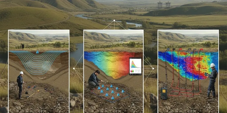
P-Wave Refraction Tomography for Rippability and Bedrock Mapping
A 24- or 48-channel spread with 10-ft geophone spacing, processed through iterative ray-tracing inversion. We deliver depth-to-bedrock contours, seismic velocity stratigraphy, and a rippability chart referenced to Caterpillar performance curves for D8 through D11 dozers. This survey is the go-to for site development in the harder metamorphic rock zones along the western edge of Forsyth County.
Combined P-Wave and S-Wave Reflection for Site Class Determination
We run a p-wave refraction line and an s-wave reflection line along the same alignment, extracting both compressional and shear velocity profiles. The output is a direct Vs30 measurement and a 2D cross-section of shear-wave velocity to 100 ft depth, compliant with ASCE 7-22 Section 20.4 for sites where a default Site Class D assumption would drive excessive foundation costs.
MASW and Seismic Tomography Integration for Restricted-Access Sites
When utility easements or tree cover limit the straight-line spread length, we combine a shorter refraction line with an active-source MASW array. The dispersion curve provides the low-frequency shear velocity constraint that a short refraction spread misses, and the joint interpretation yields a solid Vs30 estimate even on tight Piedmont residential lots.
Typical parameters
Quick answers
What does a seismic tomography survey cost for a typical Winston-Salem commercial lot?
For a single 230-ft refraction line with basic depth-to-bedrock interpretation on a cleared commercial lot in Forsyth County, the fee generally falls between US$2,690 and US$5,320 depending on line length, source type, and whether s-wave reflection or MASW is added. A site with heavy traffic control or dense underbrush will push toward the upper end because of setup time and safety requirements.
How do you handle the saprolite layer that is common across the Piedmont?
Saprolite is tricky because its p-wave velocity can overlap with highly fractured rock, especially in the 3,500–5,500 ft/s range. We process both first-arrival refraction and, where line geometry permits, s-wave reflection data that respond differently to the soil-to-saprolite-to-bedrock transitions. When we have a nearby boring log to calibrate the velocity boundary, the tomography output becomes much more reliable for distinguishing rippable weathered material from competent rock.
Can seismic tomography replace borings for a Winston-Salem building permit?
It rarely replaces borings entirely, but it can significantly reduce the number needed and position them where they provide the most value. The Forsyth County building official typically accepts a seismic velocity profile for site classification when backed by at least one calibration boring. We design the survey so the boring is placed at a location where the seismic image shows a velocity anomaly or a critical transition, giving you a defensible correlation between geophysics and direct sampling.
How long does a seismic refraction survey take, and will it disrupt site activity?
A single 230-ft line with an experienced two-person crew can be acquired in about half a day, including setup and calibration shots. The source is a weight drop or sledgehammer, so there is no explosive handling, and the surface impact is comparable to a small compactor. We can work around active grading or foundation crews as long as the spread alignment is kept clear of heavy equipment during the recording window.